NJ weather: Latest update on this weekend’s big cooldown and light snow
UPDATE... This article is outdated...
For the latest winter storm forecast information, please refer to my newest weather blog post.
UPDATE as of 8 p.m. Saturday evening...
ORIGINAL POST from 9:26 a.m. Saturday morning...
The Bottom Line
I have fielded questions from so many listeners in the past week, asking "Is winter over?" The answer, of course, is a resounding NO. Even though we're enjoyed a brief break in the constant onslaught of cold, arctic air, it's only mid-February. Big cold snaps and big winter storms are pretty typical through about the first two-thirds of March (literally until the first day of Spring). So we still have about five more weeks of regular bundling up to go.
Weather-wise, this pre-Valentine's / Super Bowl weekend is going to be quite tumultuous for New Jersey. Saturday will mark the fifth and final mild, above-normal day in a row, with temperatures flirting with 60 degrees. Thermometers will fall back into the freezer by Sunday. And we continue to track some light snow for Sunday as well.
This will not be a blockbuster winter storm — we're not getting buried in snow. But there will be some accumulations, especially on colder surfaces like grass and cars. And there could be some minor travel impacts on Sunday, especially the farther south and east in New Jersey you go. Overall, we can still call this a "conversational" or "nuisance" snow event, depending on your location and your perspective.
The Warmth
Temperatures will once again spike well into the 50s, if not 60s, Saturday afternoon. The big difference from Friday, unfortunately, will be mostly cloudy skies. The wind is going to kick up progressively as the day goes on too, sustained at 15 mph with gusts to 25 mph. A strong breeze.
We'll fare OK during Saturday's daytime hours. But colder air will start to leak into New Jersey in the evening hours. NW NJ will probably drop below freezing shortly after sunset.
The Snow
Our impending storm system does not look very impressive. Model guidance continues to show the main core of this low pressure staying way off-shore, by several hundred miles. So the piece of energy that will sweep through New Jersey on Sunday will be weak and rather unimpressive.
First snowflakes could creep into New Jersey as early as Midnight Saturday night/Sunday morning. While I expect a "mainly all snow" situation, some models do show an hour or two of slushy, sloppy rain/mix in the southern half of the state as things get started.
Peak precipitation, approaching "moderate" snow intensity, will be around sunrise Sunday, give or take.
By 10 a.m. or Noon midday Sunday, it will be all over for most of the state. Snow may linger along the southern coast into part of Sunday afternoon.
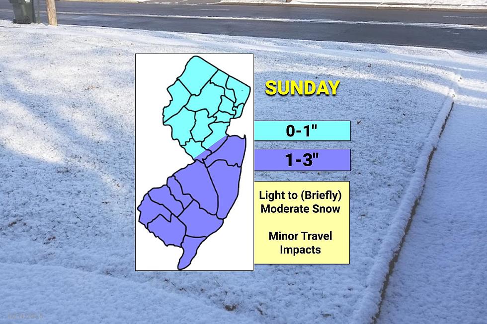
Accumulations will be light, probably falling below "advisory" criteria statewide. Probably not even "plowable" snow.
For the third time this winter, the northern half of New Jersey will find the lowest snow totals in the state, on the order of an inch (at the most). To the south and east, you're more prone to getting a band of steadier snow (I won't call it "heavier"). And there's a chance snow bands linger a bit later close to the coast. So 1 to 3 inches seems like a good broad brush estimate.
There are very few forecasters who presented totals over 2" for this storm. I decided to stick with 3" as my maximum bound because all it will take is an hour-long spurt of a stronger snow band for it to verify.
Again, light snow = limited impacts. Stay alert to minor travel impacts during and just after the snowfall. Everything should be wrapped up by Big Game kickoff time.
The Chill
In addition to the snow, cold air will take hold of New Jersey on Sunday too. Temperatures will be stuck at or below the freezing mark all day.
As skies clear Sunday night, temperatures will really tank. We'll see lots of teens on the temperature map Monday morning. High temperatures for Valentine's Day will barely touch 30 degrees. At least sunshine will return by late morning.
Tuesday will still be unseasonably cold, but a little better. Highs should push into the 30s, above freezing.
The Extended Forecast
Another big warmup will ensue next week, leading to 40s on Wednesday. Near 60 on Thursday into Friday.
Our next storm system will be a strong cold front on Friday, putting a stark end to that warming trend. Right now, that frontal boundary looks like a heavy rain maker. There could possibly be some rare February thunderstorms embedded in there, given the relative warmth and humidity built up in our atmosphere.
President's Day Weekend should mark a return to seasonable temperatures, with daily highs around the 40-degree mark. Beyond Sunday, I do not see any risk of snow aiming for New Jersey.
Dan Zarrow is Chief Meteorologist for Townsquare Media New Jersey. Follow him on Facebook or Twitter for the latest forecast and realtime weather updates.
Best coffee places recommended in Central Jersey
Census 2020: The 20 biggest places in New Jersey
More From Rock 104.1