Whiplash NJ weather: Warm for some Thursday, cold for all Friday
The Bottom Line
Even though New Jersey's weather forecast turns mainly dry through early next week (Monday into Tuesday), we are still facing some wild weather. A big partial warmup on Thursday. Followed by a big blustery cooldown on Friday.
This weekend will transition from a cold Saturday to a warmer, more comfortable Sunday.
That next storm system early next week is worth watching, for potential winter weather in North Jersey (at least).

Thursday
It is a "Tale of Two Jerseys" kind of day, with wildly different temperatures from one end of the state to the end. Warm air bubbling up from the south will battle cold air to the north. That means one end of the state will be 30+ degrees warmer than the other.
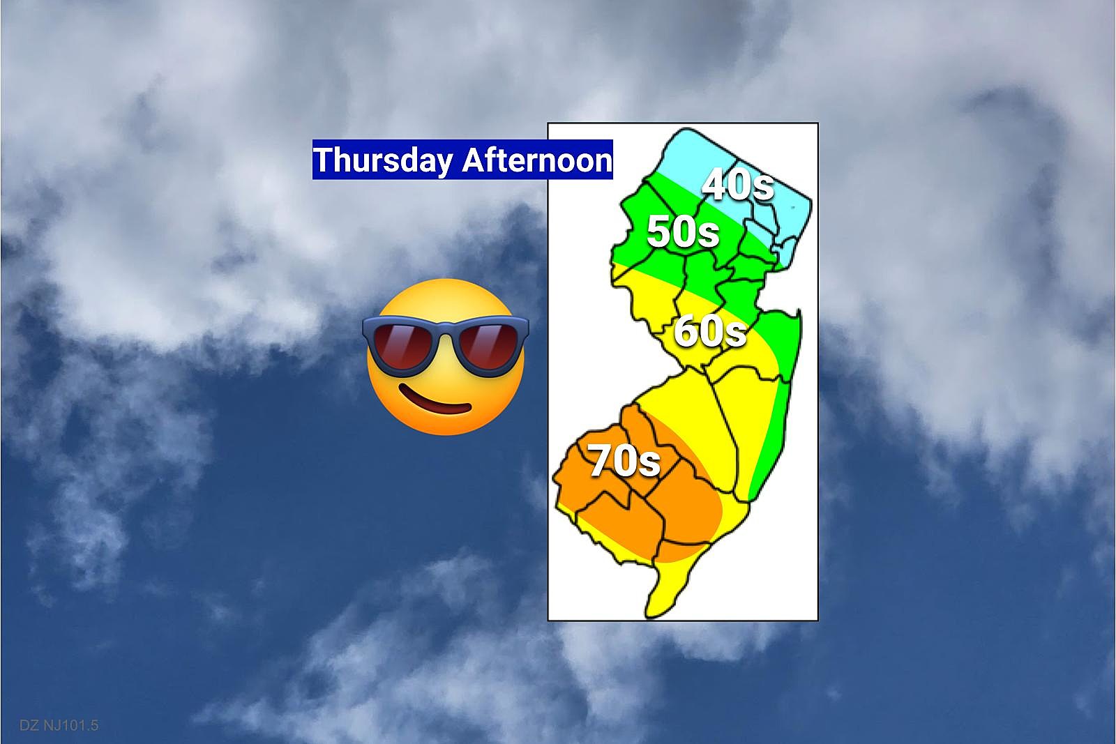
In general, expect cooler 40s and 50s in North Jersey and along the Jersey Shore. Thermometers will pop into the warmer 60s and 70s to the south and west.
Honestly, the exact detail of this temperature forecast is a wild guess. Could North Jersey get stuck closer to 40 degrees? Sure. Is 80 in play to the southwest? Yes, it's on the table.
There are some fresh puddles on the ground to start the day, after some overnight hours. And light fog is pushing visibilities as low as a mile. But the rest of the day should be clear and dry. Skies should become partly sunny (in the "cool" zone) to mostly sunny (in the "warm" sector).
Upon sunset, temperatures will dip to around 50 degrees and hover there through the night. A shower or two may clip through northern New Jersey, as a cold front inches toward New Jersey. I am also concerned that some dense fog may develop, owing to the warmth and humidity in the air.
Friday
It's another cold front day. You know the drill by now. When you hear about a cold front in the forecast, you should immediately think of three things: Cold, Wind, Precipitation.
The first two will be absolutely true. But precipitation will be minimal.
Temperatures will tumble into the 30s by late Friday afternoon. Wind gusts may hit 40 mph. Skies will clear. But it's going to be a blustery day, not a nice one.
Thermometers will keep dropping Friday night, ending up around the 20 degree mark by Saturday morning. I believe winds will die down considerably past sunset. But a little breeze will still be enough for the wind chill to bite in the teens.
Saturday
A cold February day. With two weak disturbances riding by New Jersey, to the north and the south. That will be enough to fill in cloud cover again — let's call it mostly cloudy. And we could see a snow shower at some point during the day.
Highs on Saturday will only reach the lower to mid 30s. That is actually below normal for late February. And definitely chilly, especially with very limited sunshine.
Sunday
Sunday will be the nicer day of the weekend, as temperatures return to the mild side. Latest guidance suggests highs will peak around 50 degrees, under partly sunny skies. Not bad at all.
Monday & Beyond
Our next storm system is forecast to arrive Monday afternoon, lasting through Tuesday morning. Up to an inch of rain is possible — a soaking we desperately need, after a very dry February so far.
However, this one looks interesting. For the first time in a long time, the 5 Day Forecast contains a legit shot at some accumulating. But only in North Jersey. And it will likely lean more toward a sloppy wintry mix than straight snow.
I highly recommend you keep an eye on the latest forecast throughout the weekend, as we get better resolution on whether this situation stays wintry or shifts wet.
Beyond that, I don't see any extreme warmth or cold heading into the first few days of March. Temperatures should be seasonable for most of next week, mainly in the 40s.
Dan Zarrow is Chief Meteorologist for Townsquare Media New Jersey. Follow him on Facebook or Twitter for the latest forecast and realtime weather updates.
Every Star Wars Movie, Ranked From Worst to Best
LOOK: Food history from the year you were born
Gallery Credit: Joni Sweet
More From Rock 104.1