Winter Storm Warning: 7 things to know about NJ’s Wed-Thu nor’easter
Monday's "little" storm is long gone. And our next system — the "big" nor'easter — is currently spinning over the Great Plains, right on-track and on-schedule. Forecast confidence continues to increase — I'd call it "moderate" at this point. The timing of our storm impacts here in New Jersey continues to clear up. And the accumulation forecast is slowly becoming more certain too.
The bottom line: This powerful coastal storm system will produce a wide range of impacts here in New Jersey, both in terms of geography and in terms of time. Big snow to the north. Big rain, wind and coastal flooding to the south. A mixed mess in the middle.
I have structured this blog post as a series of seven statements I (and you) can use after the storm to judge how well this forecast verified. It also makes the forecast easier to skim if you'd like. (You know, in case you're in a hurry to stock up on your important storm supplies — like bread, milk, toilet paper, and alcohol.)
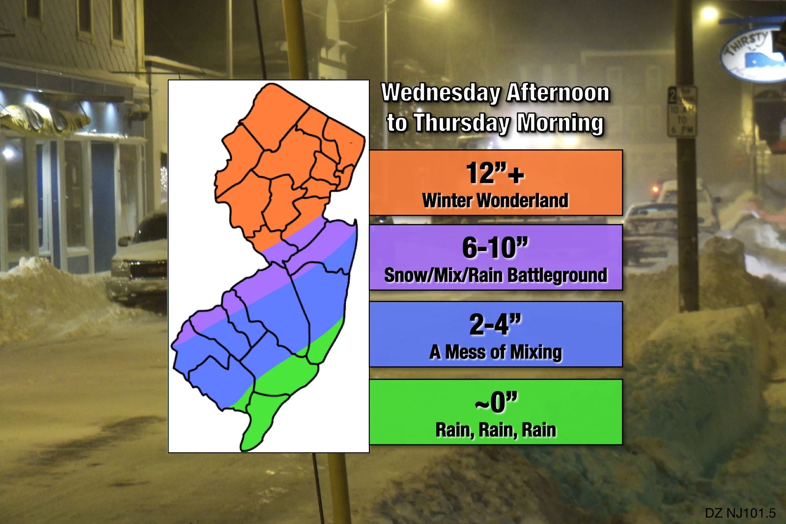
1.) Part — only part — of New Jersey will get buried by double-digit snowfall.
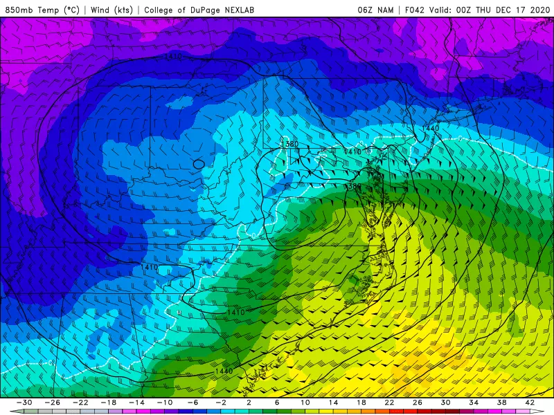
There is strong model consensus toward the northern half of the state (approximately) piling up over a foot of snow from Wednesday to Thursday. From Mercer and Middlesex counties on north, temperatures will be cold enough to sustain all snow for the duration. Snow will be heaviest from late Wednesday evening through early Thursday morning, with convective snowfall rates potentially exceeding 1-2 inches an hour.
(I've come across one model — the high-res NAM — that pushes the mixing line as far north as Interstate 78. On the flip side, the GFS pushes cold air down the I-295 corridor, promoting some big snow totals in southwestern New Jersey. They both seem to be outliers for now — but worth watching the next few runs to see how things trend.)
Some forecasters — including those at the National Weather Service — are promoting the idea of 18-24 inch snow totals across New Jersey. Wow. Such accumulations are not out of the question — but I have to hesitate. The air is going to be very dry at onset, which means snowfall may not even begin at the surface in North Jersey until Wednesday evening. Also, if the storm system wiggles slightly to the south, Sussex County gets shafted. If the nor'easter trends farther north, Mercer and Middlesex will see more mixing and therefore less snow accumulation. It's hard to forecast such historic snow unless we're really, really sure.
As you may have noticed, I decided to remove the put "upper bound" from my max snow area, settling on "twelve plus" instead. I'll probably include a top number on my next forecast map. At the moment I have to wonder: How would you prepare (physically or mentally) for a 24-inch snowstorm versus 12-inch storm? I doubt there's much difference. It's going to be big snow either way.
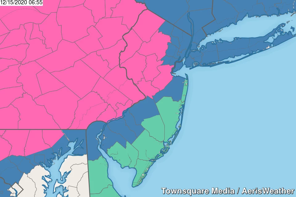
A Winter Storm Warning has already been issued for 7 counties in northern and central New Jersey: Hunterdon, Mercer, Middlesex, Morris, Somerset, Sussex, and Warren. The warning is effective 10 a.m. Wednesday through 10 a.m. Thursday.
A Winter Storm Watch continues along the periphery of that warning: Bergen, southeastern Burlington, Camden, Essex, Gloucester, Hudson, western Monmouth, Passaic, Salem, and Union. This area will be upgraded to a warning or downgraded to an advisory later today, depending on which way the snow/ice forecast trends.
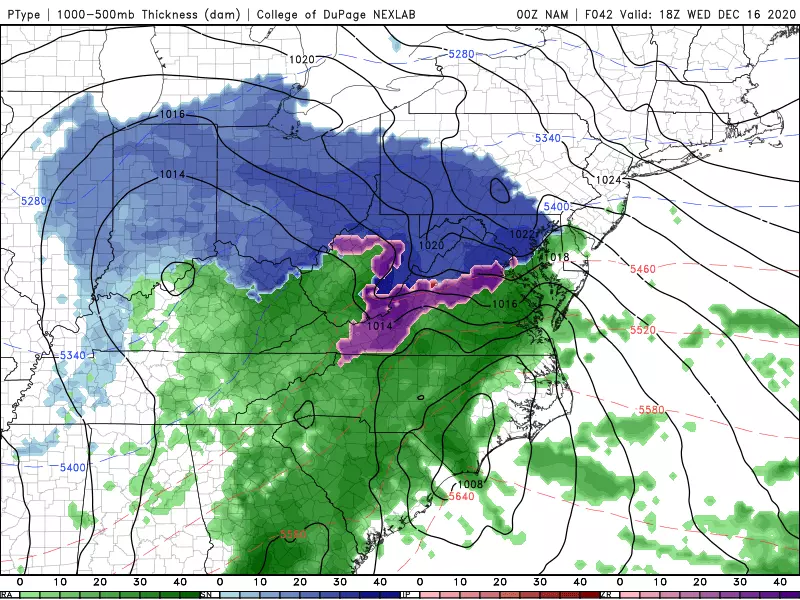
2.) Mixing/Transitions make this a "boom-or-bust" forecast.
South of Mercer-Middlesex — really southeast of the Route 1 corridor — there are serious questions about precipitation type. As temperatures throughout the lowest mile of the atmosphere hug the freezing mark, initial precipitation could take the form of either snow or plain rain. And, as we enter the peak of the storm Wednesday evening, rapid cooling and intense atmospheric energy could fuel periods of sleet and/or freezing rain. Those are absolute killers when it comes to snow totals.
I'm not sure I've ever produced a snow forecast with a discontinuity in it. (In other words, according to my map, no one would see 1" or 5" or 11" of snowfall.) I've decided on that new strategy to accentuate the difficulty in forecasting the "mixing zone". As we've discussed, there is going to be a tight gradient between "boom" (lots of snow) and "bust" (a little bit of slushy snow). It's impossible to pinpoint exactly, but this map represents my best guess.
I am quite comfortable with my snow map for now — but you know those contours are going to be nudged a few more times pre-storm. If guidance holds steady, I wouldn't be surprised if I had to ultimately decrease snow totals in the southern half of the state. Especially along the coast.
It is very clear that this won't be a big snow for southern and coastal New Jersey. But heavy rain and other impacts will be almost as severe. (Keep reading.)

3.) Wednesday morning through midday will be fine.
Over time, the forecast timeline for our nor'easter has slipped later. It looks like initial snow/rain showers will bubble up from the southwest around early Wednesday afternoon (1 p.m. ish).
That precipitation will spread north and east through the early evening (5 p.m. ish).
That late-day arrival means: 1.) The school day looks OK. 2.) Most of the workday will be fine. 3.) The evening commute will be impacted by sloppy weather and slippery road conditions.
4.) The brunt of the storm will be Wednesday night.
After sunset, all heck will break loose. The center of this strong low pressure will pass just south and east of New Jersey late Wednesday evening. So we face the heaviest precipitation through the overnight hours. If I had to put a specific time on "the brunt" I would say 8 p.m. to 4 a.m.
The "snow zone" in northern and central New Jersey will see snow pile up quickly. And as I mentioned above, rapid temperature fluxes could lead to mixing and icing through central and southern New Jersey. The strongest winds will kick up during the nighttime hours too.
5.) Power outages are likely, due to gusty wind.
Top wind gusts look to reach 35 mph across inland New Jersey and 50+ mph along the coast. Branches, trees, Christmas decorations, and garbage cans will be blown all over.
Especially when combined with heavy snow and ice accumulations, power outages are likely. Those would be potentially dangerous in such cold, snowy, wintry conditions. And potentially inconvenient for those working-from-home or attending virtual school on Thursday.
The combination of wind and snow would also lead to very low visibility. Possibly approaching blizzard conditions for a time.
A High Wind Watch is posted for Wednesday night for the Jersey Shore: coastal zones in Monmouth, Ocean, Atlantic, and Cape May counties. That is where wind gusts are most likely to exceed 50 mph.
6.) Widespread moderate coastal flooding remains a big concern.
By definition, a nor'easter brings a period of strong northeasterly winds. That is an on-shore flow for the Jersey Shore, so we do face a big surge of ocean water. Specifically during Thursday morning's high tide cycle.
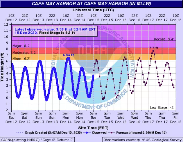
The latest tidal guidance suggests about 2 feet of water rise, which will firmly put water levels in the moderate flooding category. That goes beyond flooding in "the usual spots" and could lead to extended road closures (especially on barrier islands) and even some property damage.
The coastal flooding threat for the Delaware Bay and Delaware River will be mitigated somewhat, but still potentially in the 1 foot (minor) range.
Will the coastal flooding threat resurface during Thursday evening's high tide? Probably. Water levels will definitely be lower. But our tidal guidance doesn't "look" far enough into the future to see when water levels will substantially subside after the storm.
A Coastal Flood Watch has been issued for the Jersey Shore: Monmouth, Ocean, Burlington, Atlantic, Cape May, and Cumberland counties. I have no doubt the watch will become a warning when the time is right, on top of advisories extending further up the coast and Delaware River.
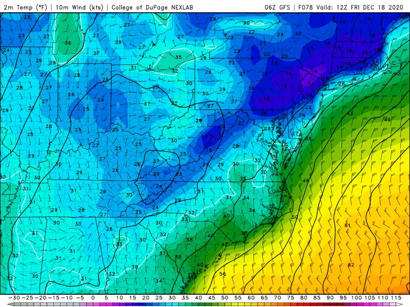
7.) After the storm, it's going to get very cold.
Partial clearing will begin immediately after the storm exits Thursday morning. But temperatures will go nowhere, with highs only around the freezing mark in the 30s. Don't expect much melt, except on blacktop and treated surfaces.
Friday morning will be particularly cold, in the teens. I estimate it will be our coldest morning since mid-February — which was the biggest cold snap of last winter.
Despite sunshine, Friday afternoon's highs will be limited to the mid 30s. (The areas with substantial snow cover on the ground will be the coldest in the state.)
Below-normal temperatures will be quite common through the rest of December. Our next storm system on Sunday will be a weak one — just a few snow and rain showers are expected.
It's time to start getting serious about storm preps and planning to keep yourself and your family safe and warm during the storm. My next weather blog update will come a little later than usual — I hope to get a new map and post put together early Tuesday evening. See you then.
Dan Zarrow is Chief Meteorologist for Townsquare Media New Jersey. Follow him on Facebook or Twitter for the latest forecast and realtime weather updates.
More From Rock 104.1