It’s Dorian Day for NJ: Here Is Your Latest Wind, Surge, and Rain Forecast
"Dorian day" has arrived. After watching this powerful, historic, and complicated storm wreak havoc on the Bahamas and the southeastern United States, it is now New Jersey's turn to taste Dorian's wrath. As the storm sideswipes the Garden State, it's really going to feel more like a nor'easter than a powerful hurricane. (Minus the snow and ice, of course.)
Bottom line?
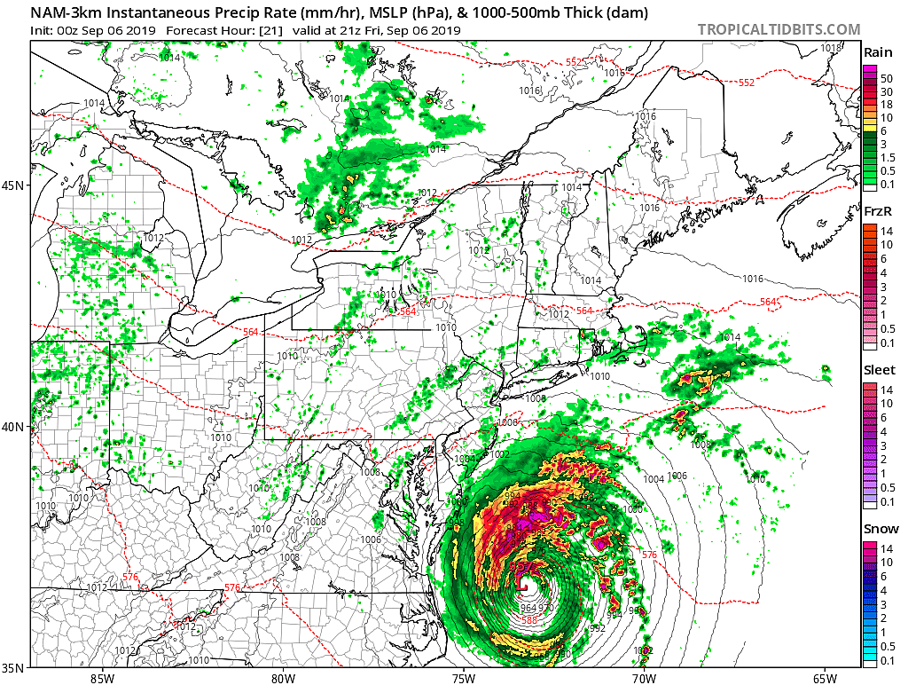
It's been a complicated forecast, and over the course of the week we have had to tweak the timing and impacts based on just how close the center of Dorian will get to New Jersey. The strongest winds and heaviest rain will stay to our southeast.
Overall, we're getting pretty lucky — if the storm had wiggled 50 to 100 miles closer, we'd be in real trouble.
Here's the latest rundown of what to expect:
1.) Friday's weather will be cruddy.
2.) The gustiest winds and steadiest rain will come Friday afternoon and evening.
3.) NJ's most significant impacts will be found along the coast.
4.) The ocean will be angry.
5.) The weekend looks good!
Where is Dorian now?
As of 5 a.m. Friday, Dorian is a category 1 hurricane with maximum sustained winds holding at 90 mph. The center of the storm is currently 15 miles due east of Cape Lookout, North Carolina. (It may or may not make landfall along the Outer Banks Friday morning — it's very close!) That makes it about 325 miles south-southwest of Cape May, New Jersey. Dorian is now charging moving toward the northeast at 14 mph.
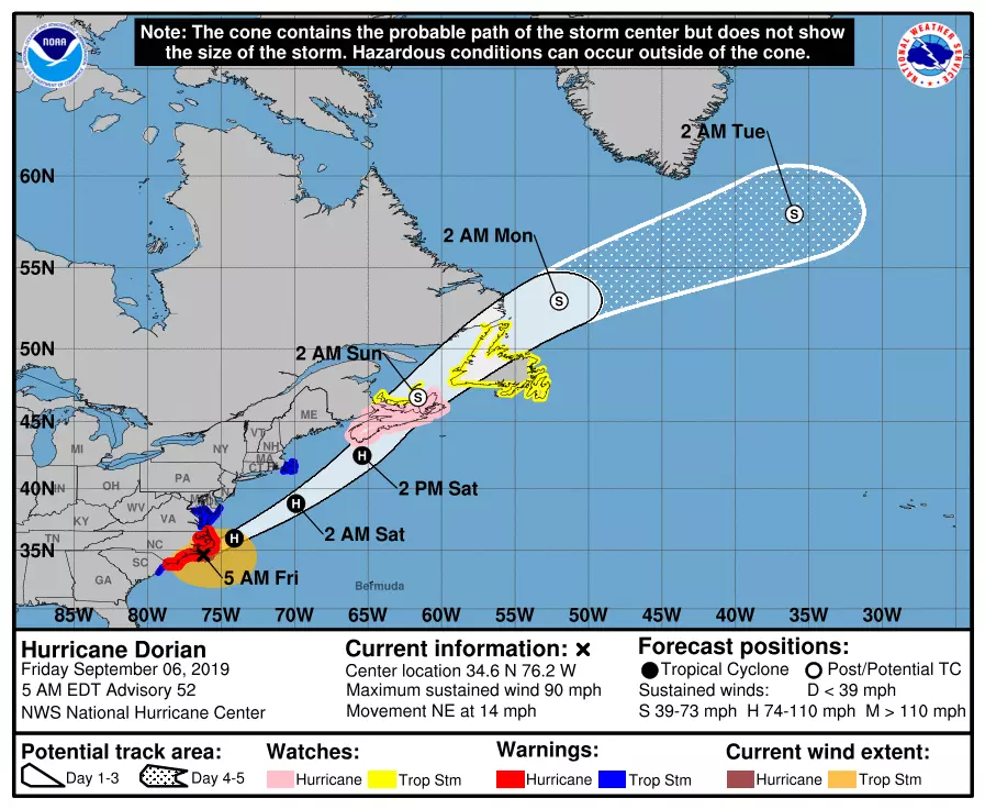
When will New Jersey start to see/feel/touch/taste Dorian?
Well, we already are. Clouds have been thickening up since Thursday, as the northern edge of Dorian encroached upon New Jersey. So far, rainfall has been limited to sprinkles along the southern coast. As of this writing, some showers are visiting southern New Jersey, and we've seen a couple of wind gusts over 20 mph.. Conditions will remain dismal and damp throughout Friday.
What are your biggest concerns, Dan?
Easy answer: the coast. We're still looking at wind gusts over 40 mph, specifically in and around Atlantic and Cape May counties. (Inland wind gusts will be closer to 30+ mph.) That is strong enough to make driving and walking difficult, break off some branches and twigs, and cause sporadic power outages.
In addition, that northeasterly wind will push some ocean water toward the Jersey Shore — A.K.A. storm surge. The magnitude of potential coastal flooding will be similar to a strong wintertime nor'easter. 1 to 2 feet of surge will cause minor to moderate flooding of tidal waterways. (I refer to this as flooding in "the usual spots".) We'll especially be watching the high tide cycle coming up Friday afternoon, as early as 2:03 p.m. on the oceanfront, as late as 6:13 p.m. along back bays. The following two high tide cycles — Saturday morning (2 a.m.) and Saturday afternoon (3 p.m.) — could run high too.
Finally — and I shouldn't have to say it, but I do — please stay out of the ocean. 6 to 10 foot ocean waves will batter beaches. A high risk of dangerous rip currents will keep red flags flying at all New Jersey beaches.
What else is coming?
Yes, it's going to rain. But I'm still thinking most of the state will see a less than a quarter-inch of rain. In fact, much of New Jersey could remain mostly dry throughout Friday.
But it will be a close call for our coastal counties, right on the edge of some heavier rain bands. Someone in New Jersey may pick up over an inch of rain — but that will be the exception, not the rule. Tropical deluges are unlikely.
The potential for lightning and severe weather is also low. It's really just some rain, blustery winds, and those coastal concerns.
When will Dorian peak here in New Jersey?
Winds and rainfall potential will max out in the afternoon and evening hours Friday. Just to be safe, I'll say those top wind gusts are expected between Noon and Midnight. My gut is saying the fiercest winds will come around dinnertime. Not a real pleasant drive home.
When will Dorian leave us alone?
By the time you wake up Saturday morning, Dorian will be almost gone. I have to include a few showers in the forecast through about 8 a.m. Saturday. But as Dorian accelerates out to sea, we'll quickly clear away to sunshine.
Winds should flip from northeasterly to northwesterly on Saturday. It will be breezy (10 to 20 mph), but refreshing.
What's next?
I'm liking the weekend forecast a lot, and I think you will too! I'll call Saturday mostly sunny, with a high temperature in the upper 70s to around 80 degrees. A few extra clouds will fill in the sky by Sunday afternoon, with thermometers slipping to the mid to upper 70s. I've seen hints of an isolated shower at some point over the weekend — but I'm thinking subsidence (high pressure, sinking air) and low humidity will make raindrops very difficult to come by.
There are several more storms in the Atlantic basin, including Post-Tropical Cyclone Gabrielle and three tropical waves. None of them pose an imminent threat to New Jersey or the U.S. East Coast.
And there are no big storms aiming for New Jersey in the next week, I am happy to say. We'll see below-normal temperatures for early next week, before a midweek warmup takes over with a few raindrops.
Please stay smart and be safe out there today. And have a great weekend!
Dan Zarrow is Chief Meteorologist for Townsquare Media New Jersey. Follow him on Facebook or Twitter for the latest forecast and realtime weather updates.
More From Rock 104.1