Tuesday NJ weather: A quick round of strong thunderstorms
It is a cold front day for New Jersey. From mild to stormy to windy to cold, your Tuesday forecast has quite a bit going on. So let's jump right in with the timing and details.
We begin this Tuesday morning with quiet weather. Early sunshine will greet temperatures in the 30s and 40s, making for a crisp and cool start to the day. High temperatures will push into the nice, mild lower-mid 60s. So far so good, right?
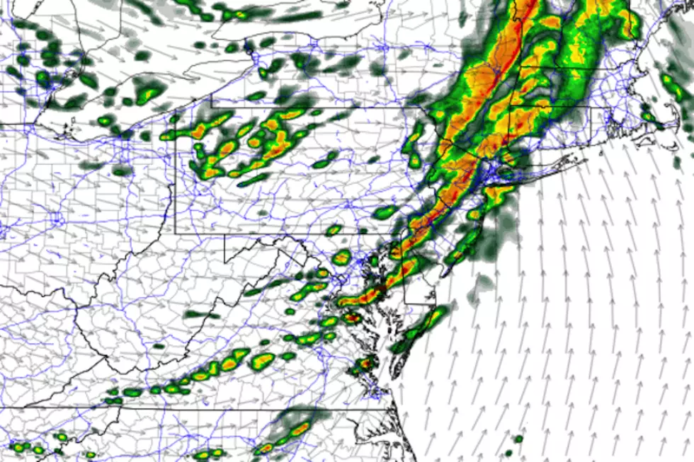
Don't let your guard down though, as a quick round of active, stormy weather is expected. Clouds will start to increase around Tuesday late morning, which may or may not be associated with a few showers. The time to really watch will be centered around Tuesday early afternoon — about Noon to 4 p.m. That's when a line of strong thunderstorms will likely sweep from west to east across the Garden State.
The storms will be quick — meaning for any given place in NJ, they'll arrive suddenly and then exit after just a few minutes. However, a brief burst of heavy rain and gusty wind (60 mph) will be possible, along with some small hail. The thunderstorms will be linear, not supercellular, so a tornado is unlikely.
The Storm Prediction Center has painted NJ in a "Slight Risk" of severe weather, translating to a 15% chance of severe (damaging) wind.
Bottom line: You don't want to be caught outside without cover when these storms roll in.
Following the thunderstorms, our new air mass will arrive with a brisk wind. Some models put top gusts at 40 mph. The National Weather Service has even gone as far as issuing a Wind Advisory for NE NJ from 5 p.m. to 2 a.m. That advisory includes Bergen, Essex, Hudson, Passaic, and Union counties.
As temperatures tumble Tuesday night, it's going to get downright cold out there. For the third time in a week, a widespread freeze is likely, outside of urban and coastal areas. (A Freeze Warning is in effect.) Low temperatures will average lower-mid 30s. And the wind chill (the "feels like" or "apparent" temperature) may dip into the 20s for much of the overnight. Yup, here we are, bundling up (and social distancing) in late April.
Wednesday will be a bright, sunny, dry day. But it will still be breezy and cool, as highs only reach the lower 50s. That's about 10 degrees below normal for this time of year. Can't complain about sunshine — just another jacket weather kind of day.
Unsettled weather returns on Thursday, with substantial cloud cover by early morning. Highs will push into the upper 50s. (Better, but still cooler than we'd like.) A shower is possible Thursday morning. And then our next chance of steady (if not heavy) rain is set to arrive late Thursday. (Right now, first raindrops looks to be from late afternoon to early evening, but I'm not 100% confident about that timing.)
Rain will carry through at least Friday morning, and then hopefully we'll see partial clearing Friday afternoon. As long as the rain doesn't linger longer than expected, highs should pop to about 60 degrees Friday.
The weekend forecast still looks shaky. But is it really possible that we could salvage Saturday after all? It would be great to have a non-washout, at the very least. Skies will be mostly cloudy, with highs near 60. Our next storm system down the line now looks to hold off until Saturday evening. But our according to the latest guidance, our weather will remain grey and damp and cool through much of Sunday and Monday.
One more reminder... New Jersey's primary weather radar at Ft. Dix, Burlington County will be offline for at least two weeks due to planned maintenance. That is particularly important given Tuesday's severe weather forecast. If you're using a radar app, you can work around the data outage using the KOKX, KDOV, KBGM, TEWR, and/or TPHL sites instead. Keep in mind, the farther away a storm is from the radar site, the higher into the atmosphere you're looking.
Be safe out there today!
Dan Zarrow is Chief Meteorologist for Townsquare Media New Jersey. Follow him on Facebook or Twitter for the latest forecast and realtime weather updates.

More From Rock 104.1


